Maps and Fires
Intriguing discoveries at the Map Library. Map Librarian, Paul Ferguson, dug out, not only the relevant Ordnance Survey maps from 1907-8 but, much more revealingly, Fire Insurance maps from 1893 and 1926, created by London-based company, Charles E. Goad Ltd, which, at 40ft to the inch, give us a great deal of useful information.

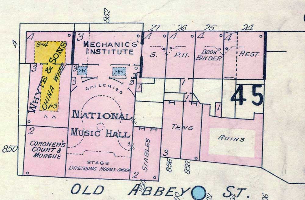
Detail of Fire Insurance Map of Dublin 1 by Charles E. Goad Ltd., 1893 (Sheet 8: 40 feet = 1 inch.) Reproduced from a map in Trinity College Library, Dublin, with the permission of the Board of Trinity College.
The 1893 map shows the “Mechanics’ Institute” on Lower Abbey Street and the auditorium, stage and galleries of the “National Music Hall” occupying exactly the locations they occupied in the Abbey Theatre following Holloway’s 1904 renovations.
Dressing rooms are indicated as being under the stage, and a dotted line outlines the distinctive horseshoe contour of the theatre’s “Galleries” (the plural probably denoting the left and right wings of the gallery with their separate doors). A small dotted circle in the centre of the stalls area suggests, in a Fire Insurance map, a large, central light fitting (chandelier?).
What would later become the Abbey’s Vestibule on Marlborough Street is, in the 1893 map, the “Coroner’s Court and Morgue”, which corresponds with Joseph Holloway’s backstage anecdote of 24 November 1904, when the Irish National Theatre Society had acquired the building, but not yet opened:
An amusing incident – an echo of the past one might term it – occurred at the Abbey Theatre this afternoon during one of my professional visits. Hearing a ring at the stage door, I opened it as I was going out and found a man, accompanied by a little boy, there, who made this inquiry: “Is there an inquest going on here to-day?”
The inquiry took me aback at first, and then I explained to him that it was a theatre, not a dead house he was at, and he departed apologising. From this it would seem that its old fame clings to the transformed morgue still.*
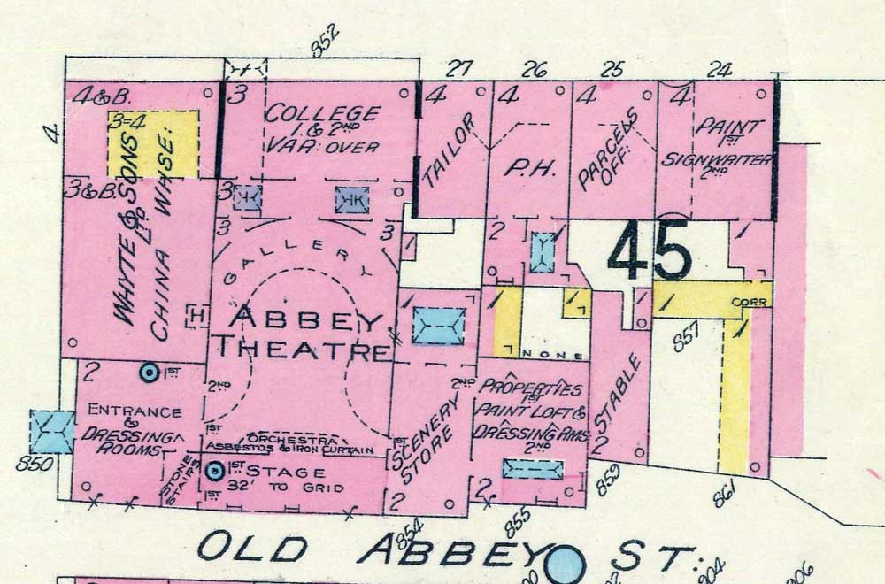
Goad’s 1926 map shows considerable changes in the architecture of the surrounding area of the city, both in design and usage, a significant amount of which must have been caused by the political upheavals of the intervening years. So far as the Abbey Theatre is concerned, however, the most significant change between the 1893 and 1926 maps is the expansion of the property owned or leased by the Abbey.

Detail of Fire Insurance Map of Dublin 1 by Charles E. Goad Ltd., 1926 (Sheet 8: 40 feet = 1 inch.) Reproduced from a map in Trinity College Library, Dublin, with the permission of the Board of Trinity College.
By 1926, this includes not only the Vestibule (described as “Entrance & Dressing Rooms”), but also the College (in place of the Mechanics’ Institute), Scenery Store (replacing Stables), and, replacing two tenement buildings, a single building having “Properties” on the 1st floor, with “Paint Loft & Dressing Rms” on the 2nd floor. The 1893 map shows two windows in the left-hand auditorium wall, but only the rearmost one survives in the 1926 drawing; an alteration for which Holloway was most likely responsible.
The large plot on the corner of Marlborough Street and Lower Abbey Street, however, remains outside the Abbey’s reach, being occupied by Whyte and Sons’ China Warehouse in both the 1893 and 1926 maps. The 1926 map notes the position of the “Orchestra” just in front of the “Asbestos & Iron Curtain” which was destined, in 1951, to save the entire collection of buildings from complete destruction.

Detail of Fire Insurance Map of Dublin 1 by Charles E. Goad Ltd., 1961 (Sheet 8: 40 feet = 1 inch.) Reproduced from a map in Trinity College Library, Dublin, with the permission of the Board of Trinity College.
A stark, white void in the final Goad map, of 1961, captures the very moment at which the Old Abbey and its neighbouring buildings have been demolished, to make way for the New Abbey Theatre.
*Robert Hogan and Michael J. O’Neill (Eds.) Joseph Holloway’s Abbey Theatre: a selection from his unpublished journal “Impressions of a Dublin Playgoer” Carbondale and Edwardsville: Southern Illinois University Press, 1967, p.47.
| Tweet |